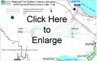
Historic Horne Lake Trail
Brief History of the Historic Horne Lake TrailSince time immemorial, the Qualicum People traveled across Vancouver Island to the Alberni Inlet via a Native trail that passed by a large lake known as Enoksasant. The trail linked coastal communities and served as an important First Nations transportation corridor on Vancouver Island. East Coast communities maintained social and economic relationships with members of the West Coast communities. The Alberni-Qualicum trail facilitated the cultural exchange of goods between two diverse eco-regions. In each region, First Nations harvested and manufactured specific cultural goods. Coast Salish baskets and Nuu-chah-nulth whale products were valuable trade items. In addition, First Nations communities exchanged mussels, camas bulbs and dentalia shells. First Nations also traveled overland for social gatherings including the Potlatch. Travel, trade and social gatherings were fundamental to First Nations communities on both coasts of Vancouver Island.
 In 1885, the Government concluded that the height of the mountain crossing along the Horne Lake Trail was not ideal for vehicles. The Cameron Lake/Arrowsmith Pass to the south was explored and identified as the new road route to link Nanaimo and Alberni. By 1889, most vehicular traffic between the two centres followed the new route and the government ceased regular maintenance of the Horne Lake Trail. East Coast and West Coast First Nations communities continued to use their traditional trail until other routes gained popularity.
District Lot 251 surrounding Horne Lake was surveyed in 1907. New owners threatened to close the Horne Lake Trail through DL 251 so the Government moved to secure the historic route in the public right and preserve it for future road development. In April 1911, H.H. Browne surveyed a 66-foot road allowance running from the Qualicum Reserve to Alberni and generally following the traditional Horne Lake Trail route. The new road allowance, formally called the Horne Lake and Alberni Road, was recognized in the provincial Gazette dated 8 June 1911. Despite occasional efforts to establish a road between Port Alberni and Horne Lake, the 1911 Gazetted Road has never been developed. Modern road development in the greater Horne Lake area, however, has generally reflected the traditional route of the Horne Lake Trail.
Further to the 2001 sale of land around Horne Lake by the Texada Land Corporation to the Horne Lake License Holders Association, the section of 1911 Gazetted Horne Lake and Alberni Road running through DL 251 was closed. The Caves Road was made a public road and widened by five metres. A one-metre right-of-way was created alongside in favour of the Regional District of Nanaimo; this public right-of-way effectively replaces the closed section of 1911 Gazetted Road. The Region will develop a multi-use recreational trail up the hillside from the Caves Road on a license basis. This upland route will connect with the section of 1911 Gazetted Road running to Port Alberni and with a trail coming up the Big Qualicum River corridor through Fisheries and Oceans Canada lands, to make a modern-day Horne Lake Trail.